
FOI: Landslide risk at Mt Warning is LOW

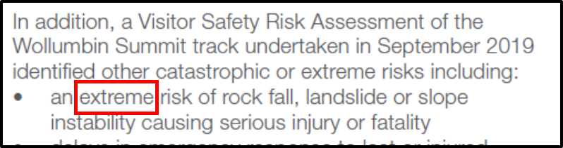
New South Wales National Park and Wildlife Service have been falsely claiming the risk of rock falls and landslides to summit track users is "Extreme". As an engineering geologist specialising in landslide risk assessment I found these claims to be ridiculous when I climbed the mountain in January. I have since discovered that NPWS organised a detailed geotechnical assessment of rock fall and landslide risk to summit track users by a leading geotechnical consultant in April 2018. However there is no mention of this report in NPWS information. It seems they are ignoring the findings of their own experts in their description of geotechnical risk on the mountain and they continue to promulgate misinformation and lie to the Minister and Public. I requested a copy of the consultant's report through the government' GIPA system and have now received a copy of the report. 

Here's an example of how NPWS continue to report on rock fall and landslide risk on the Mountain, from their November Information brochure that remains available on their website:


The conclusion of the report by GHD (available in its entirety HERE) reads as follows (our BOLD): 

The slope stability assessment has considered a broader context of the summit walking track from the carpark up to Helicopter Point 4. Numerous trackside and inferred hazards were identified. The probability of further landslides occurring is considered ‘almost certain’ yet the preliminary risk assessment suggests the overall annual risk of loss-of-life is Low. This is consistent with the anecdotal information that no injuries or fatalities have occurred, despite some 100,000 to 160,000 people walking the track each year. The lack of incidents is attributed to the very low probability that a person will be on the track and in the path of a hazard during adverse weather when the vast majority of landslide events are expected to occur. This reduction in track patronage is largely automatic with the closure of Mt Warning Road when the low-level bridge and causeway become impassable.

Despite the apparent low risk of loss-of-life from the preliminary risk assessment. Further geotechnical assessment and quantitative risk assessment is recommend to inform a track access management plan. In particular, to assist in deciding when to close the track and how strictly to enforce the closure.


NPWS have been caught lying about the Geotechnical risk of landslide and rock falls to summit track users. What will the Minister do about it?


Comments

Popular posts from this blog

Mt Warning closure - 4 years of lies and misinformation

 Mt Warning closure - 4 years of lies and misinformation March 30 (Easter Saturday) marks the 4-year anniversary of the "temporary" closure of the Mt Warning summit track. Some thoughts and rambled musings below.  I spoke with Ben Fordham about the anniversary on the Ben Fordham Breakfast show on 2GB. Ben's response a classic:  "If you want to climb, just climb it!" Link to that interview HERE . 4 year anniversary of bureaucratic madness We know the exact date of the closure thanks to bushwalker: Tertia Starr Maynard, who posted a photo of a note left on her windscreen by NPWS rangers to the reopen Facebook page . It was dated and read “NPWS advises Wollumbin National Park is closing from today due to covid19. Gate is not locked but please close behind you as you exit. Thanks NPWS.” Photo by T Maynard - the last walkers out.  In the 4 years since, after other parks were reopened, Mt Warning remained closed and the reason for the temporary closure morphed to in...

BOMBSHELL DOCUMENT LEAK - WCG MEETING MINUTES 2011-2024

 WCG MEETING MINUTES 2011-2024 We have been given access to minutes of meetings of the Wollumbin Consultative Group between 2011 and 2024. On the basis of the minutes it is clear the time for an independent public inquiry into management of Mt Warning National Park and the entire NSW Parks estate is long overdue.  Documents are made available as a matter of deep public interest in current management practices in our National Parks. What is happening at Mt Warning will be occurring in other Parks across NSW as NPWS continue to push for and develop handback and lease agreements of our public parks. In our view these plans are divisive: they prevent public involvement in managing public land, they will add considerable cost to managing our parks, and they will result in further irrational bans and limits on public access.  NPWS: "Custodians are looking at ways to progress handback at the June meeting. We envisage it will take 10-15 years for handback across the whole state."...

17th death on the Rock

17th death on the Rock ABC report that a 76 year old Japanese man collapsed on the steep part of the climb and despite first aid, was not able to be revived. The elderly Japanese man likely died as a result of heart complications, probably brought on by existing (perhaps unknown) medical conditions and over exerting himself. He appears to have died revelling in the opportunity life provides. RIP Brother of the Rock.  Our thoughts with his family and the first attenders who did their best to treat him. It's sad, but life goes on, and so should the climb. His death marks the 17th death ON the Rock since 26 May 1962 when 16 year old school boy Brian Strieff, on a school excursion with Carey Grammar, wondered off the main path in heavy fog on the way down and fell to his death. ABC's report indicate it is the 37th death, but these figures from Parks Australia have not been substantiated. It seems that many of the deaths Parks Australia claim to have occurred ON the Rock occurr...