History of the Ayers Rock
Summit Marker: a pictorial record.
Summit marker with Bronze directional plaque, circa 1970? (photo credit)
The stone pedestal that marks the summit of Ayers Rock at
865m[1], with its
distinctive bronze directional plaque features in many visitor photos. For most
visitors it marks the end of the climb and start of the return trip. The pedestal originally housed a log book where visitors once recorded their names and
thoughts. Unfortunately this logbook has been removed by Parks Australia whose on going mission has been to discourage climbing as much as possible, contrary to the concept
of what National Parks are about and the wishes of many tourists.
The current poor condition of the bronze plaque with missing
map of Australia and missing coat of arms (see below), is testament to Parks Australia’s
neglect of this important historical, cultural and scientific artefact. We hope that the
plaque may be restored to its original glory so that future climbers; those
that climb again when the nonsensical ban is lifted, may experience it as it
was intended.
This piece provides a pictorial record of the summit marker
from its first incarnation as a crude pile of stones between 1873 and 1958, to
a formed stone trigonometric cairn with a pole and vanes between 1958 and 1970,
to its current form from 1970 to present.
There is some conflicting information about some of the
dates presented and we will update the timeline when and if better data comes
to hand. If anyone objects to photos being used let us know.
1873-1958 A pile of
rocks
The original summit marker was a crude pile of stones first arranged
by William Gosse in 1873 and added to over the years by various visitors. Alan
Breaden reportedly left a match box tin in the cairn when he climbed with David
Oliver in 1896[2] (or possibly 1897[3]). This was
retrieved by Constable William McKinnon in the early 1930s. McKinnon left a
small glass jar at the cairn and until the late 1950s (?) this contained a
record of climber’s names. The Mt Olga-Ayers Rock research expedition of August
1950 made a record of the list
of names in the glass jar at the cairn at the summit of Ayers Rock.

Constable William McKinnon at the Cairn, probably 1932. Photo credit The
Queenslander 10 June 1932

The Cairn at the top
of Uluru: Tiger (Talkajyerie standing) and Tamalji seated. Taken by Arthur Groom, 1947


1952 One from a collection of photographs taken by Kevin Harris, a long time employee of Bond's Bus Tours. Kevin Ray and his assistants at the cairn on the top of Ayers Rock.
1958-1970
Trigonometric station – the cairn.
In 1958 the Division of National Mapping replaced the small
stone pile with a large stone cairn and trigonometric survey marker with pole
and vanes as part of a National mapping program. The cairn formed the backdrop
to a growing number of climbers between 1958 and 1970.

First woman climber was Beryl Miles.

Cairn in 1970, rocks rearranged to provide a seat. Photo credit Jeff Carter.

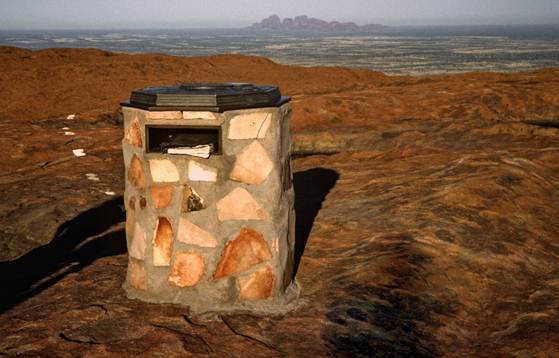
1970-present: Stone pedestal with Bronze directional
plaque.
The survey cairn was replaced by a
more formal stone pedestal and bronze plaque featuring a directional compass,
map of Australia and an Australian Coat of Arms in November 1970. The pedestal
housed a record book for climbers to record their names but his is no longer
serviced by Parks Australia. Over time the Map of Australia and Coat of Arms
have been stolen. The map of Tasmania disappeared sometime between 1970 and
1977. The rest of Australia vanished in the early 1980s, likely between 1982 and 1984
along with the Commonwealth Star and part of the Emu’s wattle. The rest of the coat of arms vanished between 1998 and
2003.
Sadly Parks Australia do not seem
to have any interest in maintaining this important historical, cultural and
scientific artefact.

Ayers Rock summit Station Summary showing construction details of pedestal. There is a 5 cent piece under the centre of the survey mark.

Bronze directional marker prior to installation by Division of National Mapping, 1970. Note Map of Australia and Coat of Arms. (photo credit)
See the post Ayers Rock Geodetic Station for photos showing the pedestal being constructed.
Pedestal under construction.
The rocks used to render the pedestal were imported from Mt Conner. Carried up the rock by NT Parks Staff. Left to right George Page-Sharpe, Derek Roff (Head Ranger), Ian Cawood and Darrel Toon. See Ayers Rock Geodetic Station

See the post Ayers Rock Geodetic Station for photos showing the pedestal being constructed.

Pedestal under construction.
The rocks used to render the pedestal were imported from Mt Conner. Carried up the rock by NT Parks Staff. Left to right George Page-Sharpe, Derek Roff (Head Ranger), Ian Cawood and Darrel Toon. See Ayers Rock Geodetic Station

Summit marker with Bronze directional plaque, circa 1975? (photo credit )


Ayers Rock Summit Pedestal 1977. Photo Credit


Directional Plaque, probably 1984. Australia and Commonwealth Star, and part Emu’s Wattle motif missing. Photo Credit


[1] Height is reported to be 877m ASL according to CR Twidale, 2010. See Uluru (Ayers Rock) and Kata Tjuta (The Olgas): Inselbergs of Central Australia in Geomorphological Landscapes of the World edited by Piotr Migon Springer Science & Business Media 2010
[2] Healy, T. (1995) The early ascents of Mount Olga, Burwood, self-published. Reproduced on P16 in Hannah Hueneke 2006 To climb or not to climb? ‘The sacred deed done at Australia’s mighty heart’ ANU Honours Thesis.
[3] https://trove.nla.gov.au/newspaper/page/2368137 The Queenslander Thu 30 Jun 1932 P24
Comments
Post a Comment