The first professional tourist guide books about Ayers Rock and The Olgas were published in (about) 1961. These were authored by anthropologist Charles Mountford and artist Ainslie Roberts.
The titles include "Your Guide to Ayers Rock" and "Your Guide to The Olgas"
Images of some of the pages are provided below. These booklets provide a wonderful overview of the area and Aboriginal myths associated with both locations. Modern guides are quite lacking in comparison.


The Olgas Guide book includes some directions about climbing to the summit cairn of Mount Olga, this is a much more difficult task than walking up Ayers Rock. (Note climbing Kata Tjuta/Mt Olga is banned under the current management plan).
"To reach the starting point of the climb to the summit of Mt. Olga, travel along the western side of Katajuta until almost opposite the western face of Mt Olga and the mouth of the Walpa Gorge (map, p.6). Near the side of an old road is a pile of stones and a bloodwood tree with a blaze on one side (see sketch). Standing beside the tree, examine the western face of Mt. Olga, and identify the faint, dark watercourse, which, starting near the summit, runs into a series of dark-coloured areas. Most of those are very faint, but the deepest coloured of them (the second from the south) provides the easiest route to the summit. At the same time, and from the same position, identify the curious S-shaped wall high up the face of Mt. Olga, and use it as a guide for climbing. The best route to the top passes a few yards of the southern face of this wall.
Having established these climbing points in your mind, then set out on your adventure. Walk approximately two hundred and fifty yards in an easterly direction until you locate a isolated green-leafed desert poplar. The turn south-west for another one hundred and eighty yards, where you will find a small cairn of stones. this is the real starting point of the ascent.
When climbing, stop now and again, both for a rest and to map out the route as far as you can see. And, as you climb, build small piles of stones to guide you on your return journey. use strong footwear (under no conditions attempt the task with bare feet) and test all projecting stones before putting any weight on them. It is much safer, always, to use the indentations, not projections, as footholds."
A video of the climb done in 1988 can be viewed on You tube.
The titles include "Your Guide to Ayers Rock" and "Your Guide to The Olgas"
Images of some of the pages are provided below. These booklets provide a wonderful overview of the area and Aboriginal myths associated with both locations. Modern guides are quite lacking in comparison.
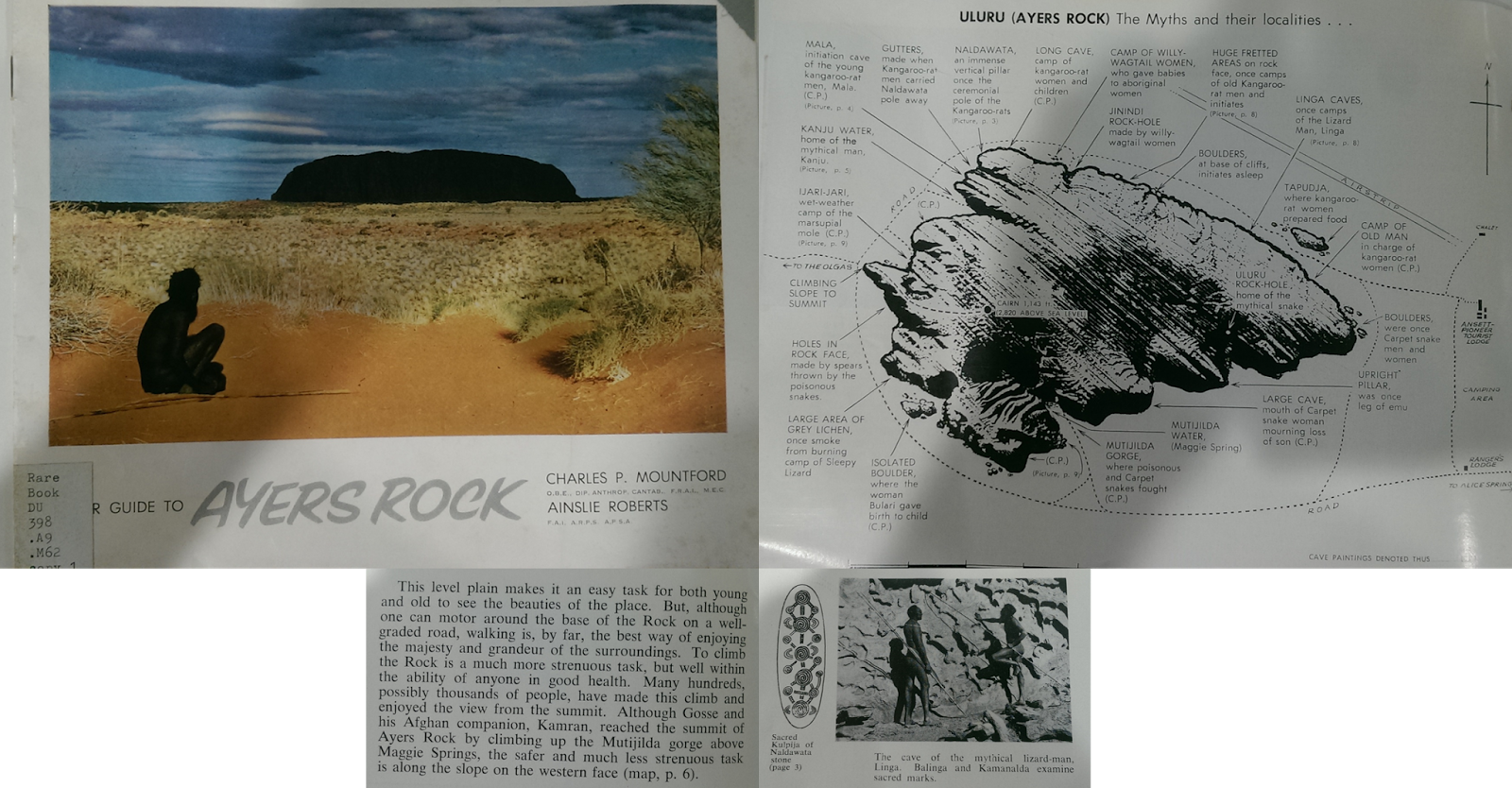
A few pages from Your Guide to Ayers Rock
About the Ayers Rock climb the guide states:
"To climb the Rock is a much more strenuous task, but well within the ability of anyone in good health. Many hundreds, possibly thousands of people, have made this climb and enjoyed the view from the summit."
A few pages from Your guide to Mt Olga
The Olgas Guide book includes some directions about climbing to the summit cairn of Mount Olga, this is a much more difficult task than walking up Ayers Rock. (Note climbing Kata Tjuta/Mt Olga is banned under the current management plan).
"To reach the starting point of the climb to the summit of Mt. Olga, travel along the western side of Katajuta until almost opposite the western face of Mt Olga and the mouth of the Walpa Gorge (map, p.6). Near the side of an old road is a pile of stones and a bloodwood tree with a blaze on one side (see sketch). Standing beside the tree, examine the western face of Mt. Olga, and identify the faint, dark watercourse, which, starting near the summit, runs into a series of dark-coloured areas. Most of those are very faint, but the deepest coloured of them (the second from the south) provides the easiest route to the summit. At the same time, and from the same position, identify the curious S-shaped wall high up the face of Mt. Olga, and use it as a guide for climbing. The best route to the top passes a few yards of the southern face of this wall.
Having established these climbing points in your mind, then set out on your adventure. Walk approximately two hundred and fifty yards in an easterly direction until you locate a isolated green-leafed desert poplar. The turn south-west for another one hundred and eighty yards, where you will find a small cairn of stones. this is the real starting point of the ascent.
When climbing, stop now and again, both for a rest and to map out the route as far as you can see. And, as you climb, build small piles of stones to guide you on your return journey. use strong footwear (under no conditions attempt the task with bare feet) and test all projecting stones before putting any weight on them. It is much safer, always, to use the indentations, not projections, as footholds."
A video of the climb done in 1988 can be viewed on You tube.
Comments
Post a Comment